Jammu Kashmir and Ladakh
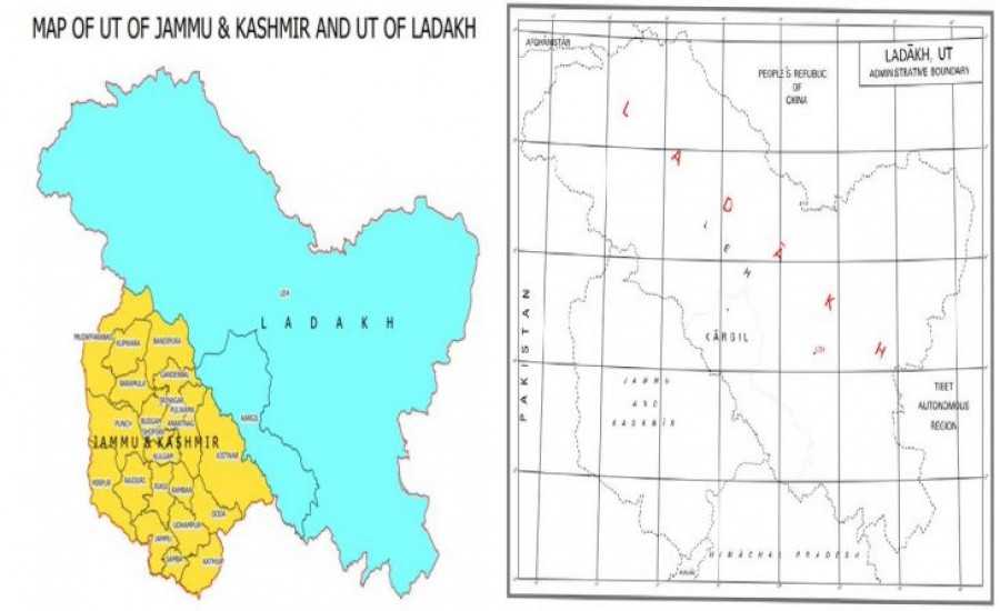
On the occasion of the birth anniversary of Sardar Vallabhbhai Patel, the first Home Minister of independent India, on 31 October 2019, the Government of India has released a new map of the Union Territories of Jammu and Kashmir and Ladakh. Along with this, the new political map of India was also released by the Surveyor General of India. In this map, India has given a tough call to the neighboring countries Pakistan and China and has also specially shown Mirpur and Muzaffarabad of PoK in the map of India.
Also read: Jammu Kashmir Reorganization Bill 2019 | How does state reorganization take place?
Formation of Union Territories of Jammu-Kashmir and Leh-Ladakh
Article 370, which gave special status to Jammu and Kashmir, was completely abolished by issuing a notification by the President on August 5. For this, India’s Home Minister Amit Shah had presented a resolution in the Rajya Sabha on 5 August 2019. In which according to the new government order, all sections of Section 370 were abolished from Jammu and Kashmir. Only one section of this was kept effective. The second biggest decision taken was that Jammu and Kashmir will no longer be a state. It was divided into two union territories, Jammu-Kashmir and Leh-Ladakh.
Also read: What is Section 370
Also read: What is Article 35A?
Now extent and map of India map
Before the removal of Article 370, this was the border in the map of India , but Mirpur and Muzaffarabad were not shown clearly. After the implementation of the new law in Jammu and Kashmir, a total of 22 districts have been formed, to which Mirpur and Muzaffarabad have also been added. Apart from this, two districts Kargil and Leh have been formed in the Union Territory of Ladakh.
Also read: What is the meaning of Section 144?
Names of 22 districts included in Jammu and Kashmir UT
In 1947, the state of Jammu and Kashmir comprised 14 districts, but by 2019 their number had increased to 28. Now after the formation of the new Union Territory, Jammu and Kashmir has Kathua, Jammu, Samba, Udhampur, Doda, Kishtwar, Rajouri, Reasi, Ramban, Poonch, Kulgam, Shopian, Srinagar, Anantnag, Badgan, Pulwama, Ganderbal, Bandipora, Baramulla, Kupwara, Mirpur and Muzaffarabad districts have been included.
Also read: What is UAPA Bill?
Districts included in the Union Territory of Ladakh
Ladakh was earlier a part of Jammu and Kashmir but now the government has made it a Union Territory . In which two districts are included, Leh and Kargil. Of these, Pakistan occupied Gilgit-Baltistan has also been included under Leh. Gilgit, Gilgit-Wazarat, Chilhas, Tribal Territory have also been included in Leh.
Also read: How is President’s rule imposed in the state?
Also read: What is no-confidence motion and trust vote?
Here we have provided information about the names and map of the districts of Jammu and Kashmir and Ladakh. If you have any question in your mind related to this information, or want to get any other information related to it, then comment. You can ask through the box, we are waiting for your feedback and suggestions.
Also read: Who is Jaish-e-Mohammed, complete information
Also read: Neighboring countries of India and their capital, currency
Also read: How many states are there in India?
Also read: What is surgical strike and how does it happen?
Also read: How did India become independent in 1947?
Also read: When is President’s rule imposed in the country and state?

